N E I G H B O R S A S S O C I A T I O N ( L I N A )
m a p o f t h e a r e a
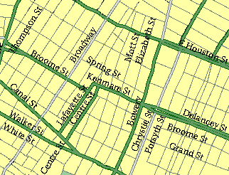
Little Italy, shown on the above map, is located between Houston Street, Canal Street, Lafayette Street and the Bowery. This area also includes part of Chinatown. West of Little Italy is SoHo; north of it is NoHo; east of it is the Lower East Side, and to the south is the remainder of Chinatown.
The neighborhood is served by several subway lines, including the East Side IRT, i.e., the 6 train (Spring Street and Canal Street stations), the BMT Broadway, i.e., the J and M trains (the little known, rarely used, and crumbling Bowery station) and the IND Sixth Avenue, i.e., the B, D and F trains (Broadway/Lafayette and Second Avenue stations).
More detailed glimpses of Little Italy, showing its manufacturing lofts, religious institutions and, above all, tenements, are available from a 1917 land map.